Hi guys, today’s post is all about the Colorado River in Texas.
From the geographical classes, you remember that the river flows through the southern United States.
But did you know that it is the longest river to flow entirely in Texas?
YES!
The Lower Colorado River meanders through the center of Bastrop County and the towns of Bastrop and Smithville.
Its watersheds and some of its (usually dry) tributaries extend into New Mexico.
Texas is generous about rivers and lakes; it has 3,700 rivers with a combined length of approximately 80778.255 miles.
The largest rivers of Texas are the Red River, Trinity, Brazos, Colorado, and Rio Grande, and many small rivers in the central and western parts often dry up.
The state of Texas has several natural lakes and several hundred artificial lakes.
They were designed to provide electricity, store water, and water farms.
Among the largest are Lake Texoma (partially in Oklahoma) on the Red River, Lake Travis on the Colorado River, and Levingston Lake on the Trinity River.
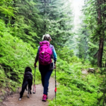
Can You Swim in the Colorado River in Bastrop?
Yes, you can swim, and the river has become extremely popular (especially during summer vacations and holidays).
There’s plenty to do here, whether you’re looking for a more passive or active getaway.
If we talk about different parts of the Colorado River, like Arizona, then a river walk along the Colorado is a fascinating trip through time, on which you can personally see how the river made its way through the mountain deposits of different periods.
Travelers who decide to visit these places are waiting for unique pictures of nature: huge rocks, cactus groves, waterfalls, and streams with crystal-clear water.
On its descent from the Rocky Mountains, the river has created the grandiose Glenwood Canyon, which reaches 12 miles in length and whose walls rise 1280 feet above the river level.
In the canyon, you can find therapeutic geothermal pools with mineral water and mineral steam caves, which, after visiting, can have a significant therapeutic effect.
Further, the river passes through the Colorado Plateau and Arches National Park, where the Upper Colorado River Scenic Byway is laid along the reservoir.
The road follows the river for a distance of 43 miles, meandering among the majestic mountains, which consist of red sandstone.
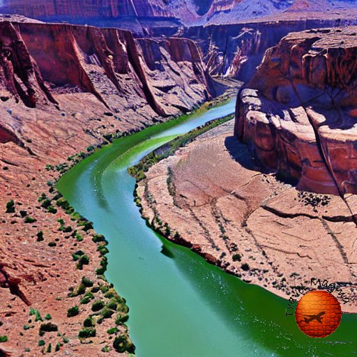
Near the Glen Canyon Dam, the riverbed makes a gradual bend, which forms the unique beauty of the Horseshoe Bend landscape.
Oh, I am sorry, I got a little off topic.
Let’s come back to Texas🤣…

What Kind of Fish Are in the Colorado River in Bastrop, TX?
Due to my research, the river itself was once inhabited by 49 species of fish, of which 42 were endemic.
However, engineering projects along the river have affected at least 40 species, whose populations have declined significantly.
Some endangered species include the sharp-tailed sucker, bone-tailed chub, humpback chub, and Colorado walleye.
Right now in Colorado, there are different types of fish that can live in cold water, including trout, rainbow trout, and cutthroat trout.
And everything would be fine if not for the fact that these predators destroy small, young local fish.
Which leads to the extinction of many species of local fish and, accordingly, the destruction of a unique, natural habitat.
In order to correct the current situation, scientists decided to periodically drain the waters of the lakes so that the silt accumulated in them would fill the waters of the river and restore its sandy banks.
And since 1996, Lake Powell has periodically become shallow, and the waters of Colorado are filled with life-giving silt.
Unfortunately, the first flood of the river did not lead to significant results.
The pressure of the water discharged from the lake was not enough to restore the sandy shores of Colorado, wash away non-native fish species, or destroy algae growing along the side of the river.
It was also not enough to flood the coastal beaches and islands that were previously hidden by water.
During the first discharge of water, scientists found that the proposed coastal zone was practically free of the sand that had previously covered it.
Later, organized floods were more successful.
Predatory fish have not left the fertile waters of Colorado, but their populations have decreased, and populations of native fish species have increased by 50 percent.
In addition, before carrying out artificial flooding of the river, scientists dumped sand into its waters in order to restore the original coastal bottom.
Nowadays, fishing also takes place, but it is often complicated by the fact that many parts of the river in the basin are polluted by industrial and agricultural effluents.


Your Ultimate Caribbean Adventure Awaits!
Discover hidden coves, secret beaches, and the best rum punches in the islands. Your insider’s guide to Caribbean paradise.
Get Your Guide Now$15.99Colorado River at Grand Canyon
Well, my story won’t be completed if I don’t mention the Grand Canyon and where the Colorado River formed the gorge.
I explored the Grand Canyon by camping on the banks of the Colorado River during river tours through the canyon because I wanted to go down inside the canyon, and I planned an overnight stay in the Colorado River Valley.
Grand Canyon Park is undoubtedly one of the largest and most world-famous national parks in the United States, which, without exaggeration, is today considered one of the most outstanding natural wonders of the world and was included in 1979 in the UNESCO World Heritage List.
It is located in the territory of a huge canyon formed by the Colorado River more than 5 million years ago.
The name of the Grand Canyon in the United States was not accidental, because it really is the largest canyon on the planet but not the deepest in the world.
Since we arrived at Grand Canyon Park in October, when the number of visitors was significantly reduced compared to the summer season, we walked the trails in Grand Canyon Park on foot all the time.
I chose to explore the Grand Canyon by walking, and it was suitable for me because I went where I wanted, slowly examining all the details.
This is the slowest way to explore the Grand Canyon, but most experienced hikers, many visitors, and I choose it.
Among other things, you can walk from the North Rim of the Grand Canyon to the South Rim and back, but it will take at least 3–4 days.
It is most reasonable to combine walking with shuttles in the park where possible.
Well, that’s all for today, and I hope you enjoyed it!