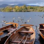
The Okeechobee waterway is the first course of water you will sail on if you are boating in an anti-clockwise direction on the loop.
I have used the Okeechobee Waterway to visit some places in Florida.
How long does it take to cross the Okeechobee Waterway?
It can take me about two days before I can complete the journey.
The intention of developing the waterway was to shorten the distance around the peninsula, for easy pass through the state by commercial ships.
It is still serving the same purposes today, but the waterway is being used by many boaters like us for recreation.
How long does it take to cross the Okeechobee Waterway?
It will take about 2 days to get from end to end because the waterway is about 154 miles long.
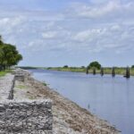
There is an inside protection arrangement in the Okeechobee Waterway for boaters sailing from the Atlantic Ocean to the Gulf of Mexico, across the Florida Peninsula.

At Stuart, Florida, about 80 nautical miles south of Cape Canaveral, on the east coast of Florida is the eastern entrance to the Okeechobee Waterway.
You will see the western entrance at Punta Rassa, Florida, about 77 nautical miles south of the entrance to Tampa Bay on the west coast of Florida.
The Okeechobee Waterway Lock System
If you want to sail across the Okeechobee waterway, you have to pass through some locks and bridges.
Before you embark on the journey, there are five locks you have to be educated about.
They are
- Moore Haven lock
- P.
Franklin lock
- Lucie lock
- Port Mayaca lock
- Ortona lock
You can communicate with the lock master via channel 13 (VHF).
Protect your boat from the hard walls of the locks by keeping your fenders out.
As you are in the lock, make sure you put on your PFD.
Navigating through the Okeechobee Lock System
There are between 25 to 27 bridges across the Okeechobee Waterway, so for you to cross the Okeechobee waterway you have to pass under the bridges.
It is your choice to choose how you will cross the waterway.
Port Mayaca RR Lift Bridge is the lowest of all the bridges at a vertical clearance of 49′.
You do not have to wait for a low water current to go through the bridge because the sea level has already locked you through.
A story has been told of a company that uses barrels filled with water as a temporary tool to reduce the height of monohulls that are a bit too tall to heal them over and get them across under the bridge.
These bridges are a great resource.
If you want to know everything about their clearances and operating restrictions,.
To maintain communication with the opening bridges, you have to be on channel 13 via VHF radio.
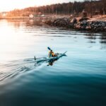
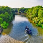
You can stop along the Okeechobee Waterway and dock for free.
The state of Florida has a rich boating historic past, the Okeechobee Waterway, and the towns and cities along it are a big part of the history.
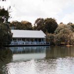
As you boat along the waterway, there are many places you can stop over such as Stuart, Indiantown Marina, Moore Haven City Dock, Port LaBelle, and Clewiston.
You will either find a free dock or a cheap dock in these stopover spots.
It is nice you call in advance for a reservation.
It is advisable to first stopover at Stuart to restock your groceries or boat provisions before you boat on.
Navigation Season
Navigation on the Okeechobee Waterway does not have any formal season.
Ships are free to pass through it at all times of the year, subject to available water depth.
Weather, lock operating hours, and construction or maintenance of waterway structures are the critical factors one has to put into consideration when navigating the Okeechobee Waterway.
The authorities in charge of the locks post the lock operating hours and non-emergency maintenance or construction in advance in the Local Notice to Mariners (NTM’s.) There can be immediate delays or total closures to the Okeechobee Waterway because of bad weather.
The Okeechobee Waterway can be closed due to thunderstorms, tropical storms, and hurricanes.
The Army Corp of Engineers has a policy they developed in managing the lock operations, to guide against these possible dangerous conditions.
Buoyage
There are red and green marks on the Okeechobee Waterway signifying the standard Aids to Navigation mark.
There are also yellow triangles or yellow squares displayed on the marks.
If you are going west of the Okeechobee Waterway which is towards Stuart and Rassa, you have to display the yellow or red triangle marks on your starboard hand.
The other marks which are yellow or green squares should be kept to port.
You have to exercise caution wherever the Okeechobee Waterway joins or coincides with channels marked by the Lateral Buoyage System because there are exceptions to every rule.
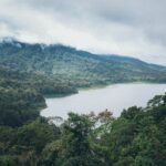
Water Levels & Channel Depths
There is a direct relationship between the navigational depths along a major portion of the Okeechobee Waterway and the water levels of Lake Okeechobee.
The American Army Corp of Engineers takes the daily water reading of the lake.
The information is used, among other things, for computation of the navigation depths and recommended drafts used by ships that sail through the waterway.
Finally, I believe with this article, you must have learned more about Lake Okeechobee.
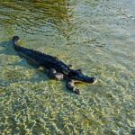
You don’t have to drink water from the lake without special treatment because it is pullulated.
FAQs
What is the speed limit on the Okeechobee Waterway?
25 mph is the speed limit in most parts of the Caloosahatchee River.

🗼 I Wrote a Book About My Japan Travel Catastrophes!
Before I landed in Tokyo, I thought I was the “Final Boss” of international travel. Spoiler alert: I WASN’T. 😅
🚅 I boarded the wrong Shinkansen and ended up in THE WRONG CITY. I confused locals with my “expert” bowing that was more awkward than accurate. I accidentally stumbled into a high-stakes Kendo practice thinking it was a tourist show. Sound like something you’d do?
“Things I Wish I Knew Before Going to Japan” is your shortcut to avoiding ALL my cringe-worthy mistakes. ✨ Inside, you’ll find practical, LIFE-SAVING tips on etiquette, transport, money, and hidden gems that will save you time, money, and a whole lot of confusion.
What is the deepest lake in the United States?
Crater Lake is the deepest lake in America and one of the deepest in the world.
The lake is 1,943 feet (592 meters) deep.
A group from the American Geological Survey thoroughly explored its depth in 1886.
How deep is the Okeechobee Waterway?
The depth of the Okeechobee Water is 8 feet.
Which was provided by the Federal project for the Okeechobee Waterway from the Intracoastal Waterway close to Stuart, through Okeechobee Lake Route 1 to Fort Myers.